10+ North Cascades National Park Backpacking Itineraries
Updated: June 3, 2026
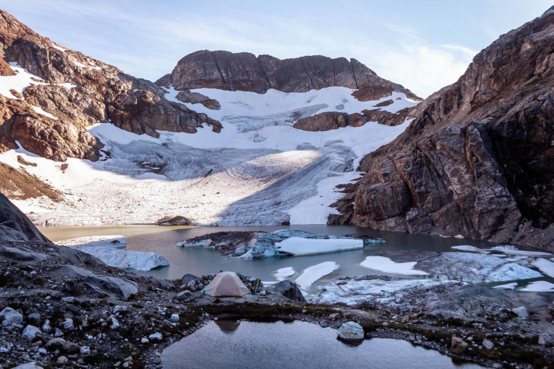
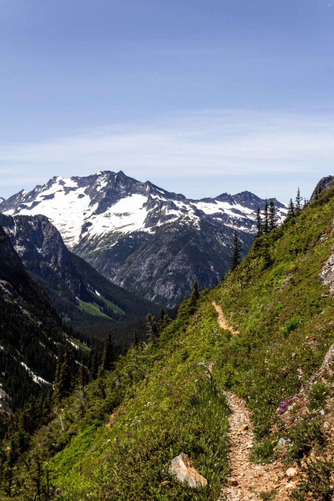
We all know about Cascade Pass. (Actually I didn’t know about its fame till relatively recently). But it’s so well known for its beautiful scenery. But getting a permit to camp there can be quite difficult since you first have to remember to apply for the lottery by March 15 for the rest of the season. And if you’re like me and always forget about permits, then you have to resort to walk-up permits in the North Cascades National Park (NCNP). You can read all about the reservation system here on their website. And even if you’re going for walk-up permits, those overnight permits for Pelton Basin or Sahale Glacier still go quick because you can get permits for the day-of or next day start. So I guess your best bet is to go extra early and camp outside the Wilderness Information Center in Marblemount the day before you want to start (just kidding…kind of).
2021 Update: And this year, 2021, the Cascade River Road is having a rough time between avalanche debris and water damage to the road, leaving it inaccessible by car past milepost 18, adding 5 miles to the Cascade Pass Trailhead each way. And at the time of this post, intermittent inaccessibility by foot traffic past milepost 20.
2026 Update: Highway 20 is closed until repairs are being made. This means some access might need a longer detour or may remain inaccessible until the road opens again.
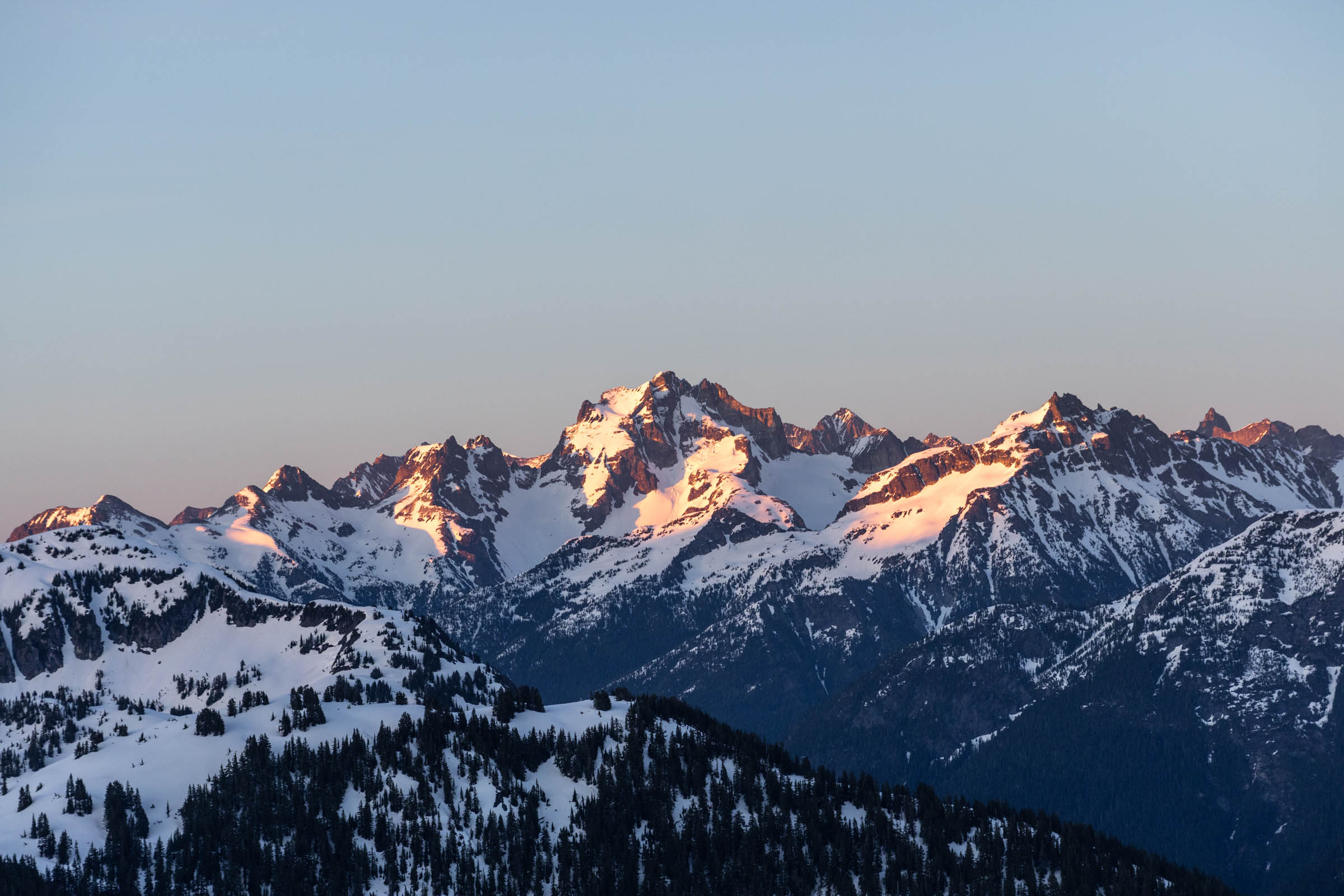
Anyway, you’re probably wondering what other trips you could do in the North Cascades. There’s actually plenty of North Cascades outside of the park without permits, but if you’re set on being close to those rugged mountains and inside the National Park, here’s several itineraries that might suit you from shorter overnight hikes to longer trips. They all get you into the alpine (as opposed to walking only in the forest, though there’s no harm in that either!). Personally for me, I would do 10-15 miles for an overnight, around 20 for 2 nights, and 30+ for 3 nights or more. But that varies from group to group, depending on how much hiking you want to do each day in terms of elevation gain and distance. So whether you want to take 5 days over 20 miles or 2 days over 40 miles, that’s totally okay!
How to Find a Trip and Get Permits in the North Cascades National Park
- Reservations: If you didn’t get a reservation in March, then you’ll probably have to do walk-up permits at the Marblemount Wilderness Information Center. This can get annoying if you want to go further out to Stehekin (out east a few hours away). Thankfully, you can email them if you aren’t starting near Marblemount (so anything Baker, Stehekin, Washington Pass-ish area). More information is located here.
- Route: But before you get that permit, you’ll need a few backup plans. The NCNP has a wonderful pdf map of all campsites and maintained trails. As you can see, there aren’t many trails, but a lot of cross country travel, but most of that requires a bit more technical work such as scrambling, rock climb, or glacier travel. This list will only offer hiking-only trips with the mildest of scrambles as a side trip.
- Campsites: Once you’ve figured out a potential trail (see below), then you’ll want to figure out campsites. Allow for more distance for middle days, and leave shorter distances or less gain for the beginning/end days so you have time to drive to/from home. I have a few suggested sites for best views/spread of mileage. The NCNP designates certain campsites as campfire permitted or prohibited as well as some boat-in campsites that are better accessed by boat.
- Permits: Even if you have a reservation, you’ll need to pick up a permit in person or coordinate with the office if somehow it doesn’t work. If you don’t have a reservation yet and need a permit, you can check what is available on the recreation.gov site. It’s a good idea to go in with 2-3 options to maximize your chances of getting campsites that make a reasonable trip for you. Another tip is to start on a weekday if it works with your schedule!
The Itineraries
Feel free to browse around this Caltopo map. It’s more interactive on the main web page here. The trips are sorted by length. The details of each trip itinerary are listed below with suggested campsites, mileage info, recommended direction of travel and more. Cross reference the official NCNP map if you’re looking for more campsites! A couple notes:
- Map legend: I use the same labeling system as NCNP. Red tents are camp fire prohibited and green tents are camp fire allowed. Those labeled permit-free reside outside the national park, but still abide by the Leave No Trace and other Wilderness rules (no campfire above 5000 ft, etc…).
- In Caltopo, click on the profile button for each route to see the elevation gain vs distance profile for each.
- Why were these routes chosen? I chose these routes because they get into the alpine with those vast mountain views that the NCNP is famous for. But if you’re more into forest hiking along creeks or lakes, there’s plenty of that too. I just didn’t list them here. And this is specifically for backpacking within the national park with permits. There’s actually plenty of non-national park trips in the general region of the North Cascades (but maybe that’ll be a post for another day!) But hint: Devils Dome can be done with no permits!
- How to use these itineraries: For each route, I give a suggested breakdowns for miles/day and campsites, but feel free to adjust to what works best for you and your finalized permits
All my best wishes for permit acquisition and happy trails!
Overnight Trips ~10-15 miles
Easy Pass
- Stats: 10 miles, 4400 ft gain
- Campsite: Fisher
- Area: Thunder / Fourth of July / Fisher / Park Creek Trails; East of Marblemount off SR-20 between Diablo and Washington Pass
- Side trips: Visit Honeymoon Hump for a short class 2-3 scramble (turn around anytime you feel uncomfortable)
- Highlights: Breathtaking into Fisher Creek and Ragged Ridge peaks, wildflowers in the summer, larches and berries in the fall
- Time: Probably best done as an overnight. Day 1: 5 miles, 2900 ft gain; Day 2: 5 miles, 1500 gain. Catch Honeymoon Hump from Easy Pass for an extra 1 mile and 1100 ft gain round trip
Hidden Lakes
- Stats: 8 miles, 4200 ft gain (some class 2 navigating boulders to the lake)
- Campsite: Hidden Lake Cross Country Zone; running water and flat ground half way towards the lake
- Area: Cross Country Zones (South of SR-20); East of Marblemount, off Cascade River Road before the gate
- Side trips: Go down to the lake or the lookout, or even scrambling to the Hidden Lake North Peak
- Highlights: Amazing views into the Eldorado Basin and Johannesburg, wildflowers in the summer, sweet evening alpenglow, if you are lucky, you could camp in the lookout but it gets busy on weekends, so the lake below is a great option
- Time: Probably best done as an overnight. Day 1: 3.5 miles, 3200 ft gain; Day 2: 4.5 miles, 1000 gain.
Thornton Lakes and Trapper’s Peak
- Stats: 10.5 miles, 3900 ft gain (including Trapper’s Peak)
- Campsite: Thornton Lake
- Area: Short Trails; East of Marblemount and before Diablo
- Side trips: Check out Trapper’s Peak from the lake
- Highlights: Incredible views of the Southern Pickets and Thornton Lakes from Trappers Peaks, blueberries in the fall
- Time: Probably best done as an overnight. Day 1: 4.5 miles, 2500 ft gain; Day 2: 6 miles, 1400 gain.
Moderate Trips ~15-25 miles
Thru-Hike Mt Ruby
- Stats: 18 miles, 6500 ft gain (including Ruby Mountain traveling west)
- Campsite: Ruby Cross Country Zone; snow persists on the north side of the mountain; other campsites like Fourth of July are near the turnoff to the summit if you want to leave overnight gear there
- Area: Cross Country Zones (South of SR-20) and Thunder / Fourth of July / Fisher / Park Creek Trails; East of Marblemount shortly after Diablo
- Side trips: The summit is optional but highly recommended
- Highlights: 360 views of the North Cascades from Mt Baker to Pickets and more, shady forest for hot days, larches in the fall and blueberries in late summer
- Time: Best done as overnight on the summit or over 3 days using Fourth of July with a car shuttle. Two days: [9.5 miles, 6400 ft] and [7.5 miles, 0 ft]; Three days: [6.5 miles, 2500 ft], [8.5 miles, 4000 ft] and [4 miles, 0 ft]
Sourdough-Diablo Lake Loop
- Stats: 19 miles, 5700 ft gain (including Trapper’s Peak)
- Campsite: Sourdough, Pierce Mountain, Green Point Boat In
- Area: Short Trails; East of Marblemount and before Diablo
- Side trips: Short 1.5 mi hike to Sourdough Peak, check out the lookout site
- Highlights: Views that rival Ruby of all around North Cascades, enjoying the lake on the way out (done as a clockwise loop)
- Time: Two Days (Pierce Mountain): [7 miles, 5200 ft] and [12 miles, 500 ft]; Three Days (Sourdough and Green Point): [3.5 miles, 4000 ft], [9 miles, 0 ft] and [6.5 miles, 1000 ft]
Longer Trips ~30 miles
Copper Ridge Loop
- Stats: 32 miles, 7300 ft gain (Caltopo claims 11000 due to all the small ups/downs)
- Campsite: Copper Lake, US Cabin (and more)
- Area: Copper Ridge / Chilliwack / Brush Creek Trails; North of Marblemount access via SR-542 by Baker
- Side trips: Tag Hannegan Peak on the way in or out, just an extra 2 mi round trip and 1000 ft gain
- Highlights: Views into the back side of the North Cascades and the Chilliwacks, alpine lakes, autumn blueberries, ridgeline hiking, old Copper Lookout
- Time: Recommended three days in clockwise loop. Day 1 to Copper Lake 11 miles and 4200 ft gain, Day 2 to US Cabin 12.5 miles and 100 ft gain, Day 3 to car 8.5 miles and 2200 ft gain; Or you can do an out and back camping at different locations on the ridge.
Goode Lookout
- Stats: 35 miles, 7100 ft gain (Caltopo claims 10000 due to all the small ups/downs)
- Campsite: North Fork (if permits are hard to get, try South Fork or Bridge Creek)
- Area: Bridge Creek / North Fork / Twisp Pass / McAlester / Rainbow Lake and Creek / McGregor and Upper Stehekin Valley Trail / Stehekin Road; East of Marblemount near Washington Pass
- Side trips: Goode Lookout is a big climb and part of this itinerary, if you have more time, check out the North Fork basin to see the back side of Logan
- Highlights: If you can’t climb Goode, at least you can get a goode look at Goode; all the goode puns and jokes, deep North Cascades views you can’t see from the highway, pass by larches in the fall
- Time: Recommended three days camping at North Fork both days. Day 1: 10 miles and about 0 ft gain, Day 2: 15 miles and 5100 ft gain, Day 3: 10 miles and 2000 ft gain
Rainbow-McAlester Loop
- Stats: 28 miles, 6400 ft gain (Caltopo claims 7600 due to all the small ups/downs)
- Campsite: Rainbow Lake, High or McAlester Lake (hard to get but there are plenty of other campsites nearby)
- Area: Bridge Creek / North Fork / Twisp Pass / McAlester / Rainbow Lake and Creek / McGregor; East of Marblemount near Washington Pass
- Side trips: You could extend it to Twisp and Copper Pass. If you have time, take 4 miles round trip to the top of Rainbow Ridge gaining 1000 ft and get a good view of Bowan Mountain. Stilletto Peak is also great
- Highlights: Especially good for larch viewing in the fall, also great for huckleberry
- Time: Recommended three days camping at the high points for maximized views. Day 1 to High 7.5 miles and 2300 ft gain, Day 2: 9 miles and 2700 ft gain, Day 3: 11.5 miles and 1400 ft gain
Thunder-Park Creek Pass
- Stats: 35 miles, 6700 ft gain (Caltopo claims 10000 due to all the small ups/downs)
- Campsite: Thunder Basin or Skagit Queen and any along the trail
- Area: Thunder / Fourth of July / Fisher / Park Creek Trails; East of Marblemount near Diablo
- Side trips: Honestly wandering around Park Creek Pass is just fun enough
- Highlights: Just to be deep in the North Cascades with views of rugged mountains at Park Creek Pass
- Time: Recommended three days camping Skagit Queen both nights. Day 1: 13 miles and 3000 ft gain, Day 2: 9 miles and 2800 ft gain, Day 3: 13 miles and 900 ft gain
Extra Long Trips ~40 miles
Devils Dome Loop
- Stats: 39 miles, 8500 ft gain (Caltopo claims 11500 due to all the small ups/downs)
- Campsite: Devil’s Creek or any along Ross Lake, otherwise permit free campsites
- Area: Ross Lake / Diablo Lake / East Bank Trail; East of Marblemount near Diablo
- Side trips: Add Crater Peak or its lookout site in the beginning of the trip
- Highlights: Ridgeline-like travel and views into the Pickets and viewing Ragged Ridge, make sure you grab water when you can because it’s a dry trail especially after Devils Dome
- Time: Recommended long three days counter clockwise. Day 1 to Nickol Creek 8.5 miles and 3700 ft gain, Day 2 to Devils Dome 12 miles and 4000 ft gain, Day 3 to car 18 miles and 800 ft gain, Day 4 to car
Thunder-Bridge Creek Traverse
- Stats: 40 miles, 4800 ft gain (Caltopo claims 9500 due to all the small ups/downs)
- Campsite: Bridge Creek and Skagit Queen (but plenty of other camps to choose from)
- Area: Thunder / Fourth of July / Fisher / Park Creek Trails and Bridge Creek / North Fork / Twisp Pass / McAlester / Rainbow Lake and Creek / McGregor; East of Marblemount near Diablo
- Side trips: Tag on Goode Lookout or go up one of the basins, or spend time at the pass
- Highlights: Amazing views in the heart of the North Cascades
- Time: Recommended long three days east to west to minimize gain and a car shuttle. Day 1 to Bridge Creek 12 miles and almost 0 ft gain, Day 2 to Skagit Queen 15 miles and 4000 ft gain, Day 3 to car 13 miles and 800 ft gain
Happy hiking! Let me know if you go on any of these trips!